
Products · Marine
Oil Spill Detection and Tracking
Find the slick through cloud and at night, then follow it as it moves.
Delivered per maritime area as a monitoring engagement; automated standing watch in development
Overview
Where is the oil, where is it going, and what will it reach?
Oil damps the small surface waves that radar reflects, so a slick appears as a dark patch against the roughened sea. The product detects and delineates surface oil from SAR imagery while separating real oil from look-alikes such as wind shadows, algal films and low-wind zones. Its value is the sequence: extent at first detection, direction and rate of drift, area at each subsequent pass, and the stretch of coastline in the path.
- C-band SAR, all-weather, day and night
- Sensor
- 1–3 days over most maritime areas
- Revisit
- Slick polygons and drift sequence
- Output
- Optical imagery, wind and current fields
- Supporting
System architecture
Schematic of the main components, from inputs to delivered outputs.
Inputs
- Sentinel-1 SAR scenes
- Optical imagery (Sentinel-2/3)
- Wind and current fields
- Infrastructure and route layers
Detection
- Dark-spot segmentation
- Look-alike suppression
- Slick delineation and area
Tracking
- Pass-to-pass association
- Drift direction and rate
- Dispersion and area change
Outputs
- Slick polygons
- Sequence map and statistics
- Coastal impact projection
- Alerts and report
Example outputs
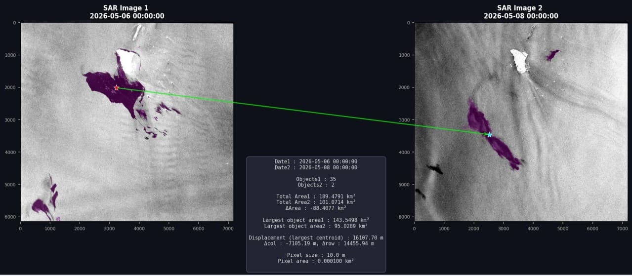
Example output: oil slicks detected and delineated on two consecutive SAR acquisitions, with the displacement of the largest slick between passes.
How it works
Pipeline and maturity of each stage
- 01
Scene acquisition
Every SAR pass over the monitored maritime area is retrieved and calibrated; optical scenes are added where available.
- 02
Detection and delineation
Dark-spot detection on the radar backscatter, with models that reject wind shadows, biogenic films and low-wind zones, produces slick polygons and areas.
- 03
Drift and evolution tracking
Detections are associated across successive passes to give movement direction, drift rate, area change and dispersion over time.
- 04
Impact and alerting
In developmentThe affected coastal stretch and sensitive receptors in the drift path are projected; alerts are issued on detection. A fully automated standing watch is in development.
Data used
- Sentinel-1 SAR
- Sentinel-2 and Sentinel-3 optical
- Wind and ocean current fields
- Infrastructure and shipping-route layers
Methods and models
- SAR dark-spot detection
- Look-alike discrimination
- Multi-pass slick association
- Drift and dispersion analysis
Outputs
- Slick polygons (shapefile / GeoJSON)
- Extent and drift statistics
- Sequence map
- Alerts and PDF report
Who it is for
- Ports and maritime administrations
- Offshore operators
- Environmental protection agencies
- Insurers and response contractors
More in Marine
All marine products- Drift and evolution trackingEngagement
- Marine pollution monitoringEngagement
- Coastal impact assessmentEngagement
- Standing watchIn development

From space. For Earth.
Start with ARASAT
Tell us what you need to monitor, understand or protect. Our team works with you from the first conversation to a running program.