
Products · Vision
Satellite Super-Resolution
Detail beyond the sensor, consistent across the time series.
Processing service delivered per area of interest
Overview
Can the detail we need be recovered from imagery we already have?
Free satellite imagery resolves ten metres; many decisions need one. Transformer-based super-resolution reconstructs structural detail lost at the sensor's native resolution in visible and near-infrared bands, with enhancement of up to ten times. It is applied across a time series rather than a single frame, so enhanced imagery stays temporally consistent and comparable date to date, and it is evaluated by the accuracy gain it produces in downstream products such as field boundaries and land cover.
- Sentinel-2 and comparable multispectral
- Input
- Up to 10×, RGB and near-infrared
- Enhancement
- Enhanced across the time series
- Consistency
- Downstream accuracy gain
- Evaluation
Example outputs
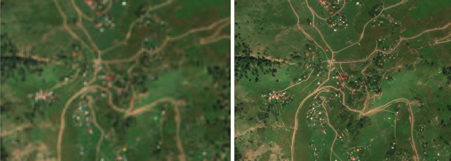
Native resolution (left) and enhanced output (right) over small-parcel farmland.
How it works
Pipeline and maturity of each stage
- 01
Paired training data
OperationalLow- and high-resolution image pairs over diverse landscapes are co-registered and processed to train the reconstruction models.
- 02
Reconstruction
OperationalDeep-learning models reconstruct edges and texture, trained so that boundary detail and agricultural texture are preserved rather than invented.
- 03
Downstream use
OperationalEnhanced imagery feeds boundary extraction, land cover, crop classification and sub-metre change detection in regions of small parcels or dense structures.
Data used
- Sentinel-2
- Comparable multispectral imagery
- High-resolution reference imagery for training
Methods and models
- Deep-learning super-resolution
- Temporal consistency across series
- Downstream-accuracy evaluation
Outputs
- Enhanced GeoTIFF
- Before/after map layout
- Input to change detection and mapping products
Who it is for
- Small-parcel agriculture
- Construction progress and compliance monitoring
- Urban and infrastructure mapping
More in Vision
All vision products- Hyperspectral analysis
- Sub-metre change detectionProcessing service
From space. For Earth.
Start with ARASAT
Tell us what you need to monitor, understand or protect. Our team works with you from the first conversation to a running program.